In early October I spent three days hiking and climbing Southern Wallowa peaks in the Eagle Cap Wilderness of Northeast Oregon. After some unsettled weather the first day the skies were clear for the rest of my trip. The scenery was beautiful – it seems we have a piece of the Colorado Rockies in NE Oregon. I saw no other person on the trails or peaks, and I had time to pause and absorb the feeling of the mountain wilderness during my long hikes.
On September 30 I drove the Wallowa-Whitman National Forest Road #77 to the West Eagle Trailhead and Campground. I claimed my campsite and settled in. I would be camping there the next three nights. As it turned out, I had the entire campground to myself each evening and night.
The last time I had been at the West Eagle Trailhead was in September of 1972. I was with a friend from high school and a college friend of his. We had attempted a backpacking loop from there, but returned early after two nights out due to snowstorms. I was in a reflective mood that evening. That night some light rain fell.
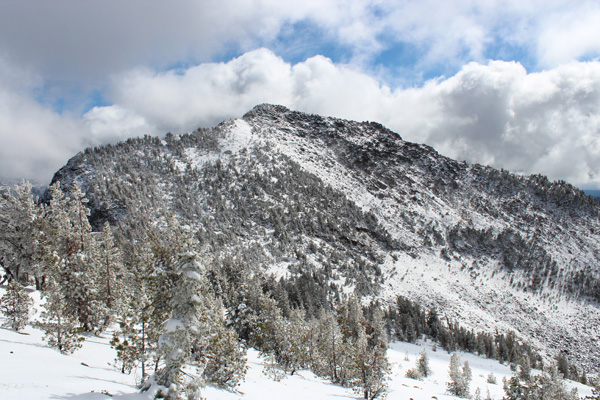
Echo Lake Northwest Peak
The next morning, October 1, I started up the West Eagle Trail. As the fog cleared I saw fresh snow on the peaks ahead of me. I forded West Eagle Creek and soon encountered a large white bull standing alongside a curve in the trail. It seemed calm and I quietly spoke to it as I skirted past. He let me pass without much reaction.
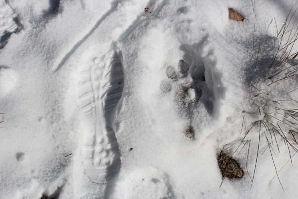
At a trail junction I took the left fork, Tombstone Lake Trail, towards Tombstone Lake. As I climbed higher I encountered fresh overnight snow on the trail. Soon thereafter I discovered fresh cougar paw prints on the trail. In the above photo I compare one of the cougar prints with my size 12 boot print. I tried to be attentive of my surroundings the rest of this trip.

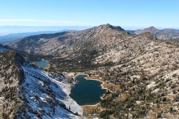
After losing the trail for a while in a snow-covered swampy plateau I regained the trail and continued along it to a pass above Tombstone Lake. Here I left the trail to climb the ridge above me to the east towards the summit of “Echo Lake Northwest Peak”. In the above photo my route climbed the snow slope on the right, then over rocks to the summit.
My hiking boots and feet were damp from climbing through snow but I was very satisfied with my climb and enjoyed the views from the summit as the clouds moved through the region. Here I studied the next day’s goal – “Traverse Lake East Peak” above the Echo Lake Basin.

From the summit I descended the same ridge towards the Tombstone Lake Trail, noting Granite Butte and China Cap to the northwest. I had climbed them in August 2013. Finding the trail I descended along it towards West Eagle Creek. I did not spot the cougar on the descent. Near West Eagle Creek I chatted with the white bull as I passed him on the trail.
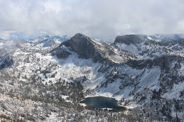
Traverse Lake East Peak

The next morning, October 2, I swapped my damp hiking boots for my climbing boots and again hiked up the West Eagle Trail, passing the white bull near where I had seen him the previous afternoon. This time I took the right fork towards Echo Lake. This was going to be my first visit to the Echo Lake Basin since 1972 and I tried to see if any of it seemed familiar.
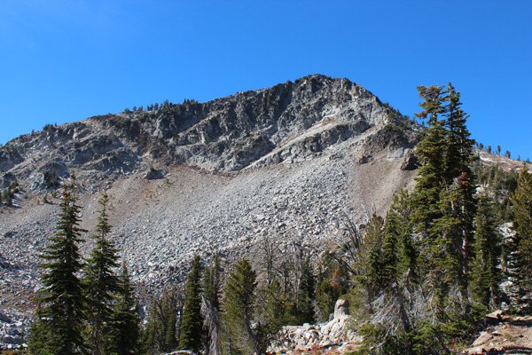
I passed Echo Lake and climbed to Traverse Lake, then left the trail. My goal was to climb “Traverse Lake East Peak”. My route would gain the saddle on the peak’s west ridge by scrambling up a rock/scree/snow slope near the center of the above photo. There was some residual snow in this gully from two nights earlier. My climbing boots are more rigid than my hiking boots and they helped me step-kick up the gully. Then I climbed just behind the ridge line around some rocky outcroppings to the summit left of center in the photo.
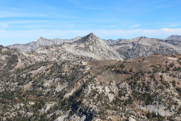
The peak had a double summit, with the eastern-most summit slightly higher. It was a sunny and pleasant day and I savored the view of Echo and Traverse Lakes and “Echo Lake Northwest Peak” from the summits. I also tried to identify tomorrow’s goal – “Arrow Lake Peak” – to the east.
I descended the same route back to camp, but missed seeing the white bull where I had seen him that morning. That evening at camp I savored my accomplishments over the past two days. I had seen no other people those days.
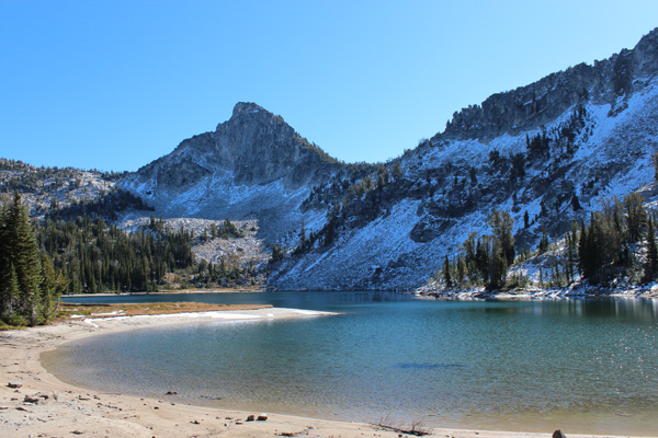
Arrow Lake Peak
The following morning, October 3, I drove to the Main Eagle Trailhead to start my hike. The campgrounds along Eagle Creek were much more popular than the West Eagle Campground. I saw many campers and a few cars at the Main Eagle Trailhead.
I hiked the Main Eagle Creek Trail #1922 north along Eagle Creek to the junction with Trail #1937, which I followed up into Bench Canyon towards Arrow Lake.
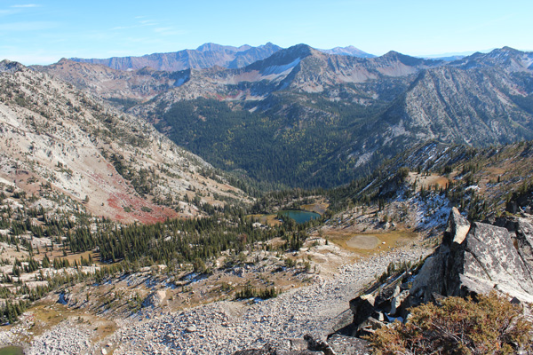
I took a break at Arrow Lake and planned my route up “Arrow Lake Peak”, which rose steeply above the lake to the west. One option was to continue north to the pass and traverse west to gain the north ridge of the peak. But I decided the most likely successful option was to traverse by the lake and gain the south ridge, then follow the south ridge to the summit, visible on the left in the above photo.
The traverse and ascent went well, with some minor rock scrambling high on the ridge to gain the summit. The views of surrounding peaks were very enjoyable from the summit. I considered how I might access those peaks in the future. Needle Point was to the northeast and “Cached Lake South” to the east. I thought it best to access them on a future trip from Cached Lake.
To the southeast was Heart Lake, the Main Eagle drainage, and “Culver Lake South Peak” rising on the other side of the drainage. Beyond that I could see Red Mountain and Krag Peak on the horizon, two peaks I hope to visit next year.
These three days of solitary camping, hiking, and peak climbing felt renewing. I look forward to many years of further explorations in the Wallowa Mountains and other mountain ranges of the US.

Great pictures..nice area..i made the loop..Echo.Traverse.Minan river.Heart lake.West Eagle.nice!!!35 years ago….bye